
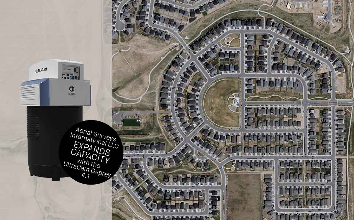
Aerial Surveys International expands capacity with UltraCam Osprey 4.1
Graz, Austria • 15 February 2023
Aerial imagery and LiDAR provider Aerial Surveys International LLC (ASI) contracted with Vexcel Imaging to acquire an UltraCam Osprey 4.1 aerial imaging system in July 2022, and the new system was operational in time for leaf-off projects that fall. The Osprey 4.1 offers dual performance as a vertical mapping camera first, then incorporating stable oblique cameras into a large format mapping solution, resulting in unprecedented flight collection efficiency.
The UltraCam Osprey introduces the 4th generation UltraCam CMOS aerial imaging sensors. A highly versatile system, it simultaneously collects photogrammetry-grade nadir images (PAN, RGB and NIR) and oblique images (RGB) in four directions. The innovative Adaptive Motion Compensation (AMC) method compensates for multi-directional motion and rotation inducted image blur and additionally compensates for ground sampling distance variations in oblique images, producing imagery with notable vividness and sharpness.
By combining industry-leading customized lens systems, next-generation image sensors with custom electronics, and a best-in-class image processing pipeline, the UltraCam Osprey 4.1 delivers imagery of exceptional quality in terms of detail resolution, clarity and dynamic range.
“Vexcel has been developing this oblique configuration for many years and has dialed in the oblique/vertical solution with a rock-solid package that makes sense for large area oblique collection with a mapping component,” said Mark Schubert, CEO and owner of ASI. “The camera is multi-purposed and will produce proven photogrammetry products with the addition of georeferenced oblique views of every side of an object. With the Osprey 4.1, the world has truly become visually 3D.”
The 4-band mapping camera with four complementing 150-Megapixel oblique cameras collects 1.2 Gigapixels every 0.7 seconds with 20,544 pixels PAN across track at nadir, resulting in fewer flight lines and therefore higher flight collection efficiency.
“A PAN channel that holds a calibrated nadir is a must—the PAN channel is what gives the stability and metric ability to the image for mapping, and the nadir capability gives us additional digital capacity complementing our UltraCam Eagle,” Schubert said. “Flying in the western region poses some unique challenges like mountains that cause turbulence and cast shadows. The Adaptive Motion Compensation helps us deal with unstable conditions while still achieving our mapping mission. We use the Osprey 4.1 because we have to be confident that our mapping products will meet or exceed specifications.”
Vexcel’s photogrammetry aerial software UltraMap fully leverages Osprey 4.1’s nadir and oblique images for aero-triangulation, allowing for highly accurate geometric results for imagery/photogrammetry and geospatial data generation such as point clouds, DSMs, DTMs and 3D TINs. From orthophotos to 3D models, the UltraCam Osprey 4.1 high-performance system sets new standards in urban mapping and 3D city modeling.
“We are pleased that ASI selected Vexcel’s Osprey 4.1 camera to meet growing demand for oblique and nadir aerial imagery,” said Alexander Wiechert, CEO of Vexcel Imaging. “The technology advancements that enable efficient large-area collection of highly accurate photogrammetric and oblique data will add value to a broad range of projects for ASI.”
About Aerial Surveys International LLC
Based in Watkins, Colo., Aerial Surveys International LLC (ASI) was formed in 1998. ASI provides clients with aerial imagery and aerial LiDAR of the highest quality and often teams with professional mapping organizations in fulfilling their aerial photography needs. ASI has successfully conducted projects throughout the United States. ASI is known for the accuracy and quality of its aerial products, the dependability of its service, and its highly skilled professional team consisting of full-time pilots, sensor operators, licensed aircraft mechanics, project managers, and data processing experts.
About Vexcel Imaging
Vexcel Imaging, a global leader in aerial imaging, develops cutting-edge large-format aerial cameras and photogrammetric software with innovative approaches, and places an emphasis on continuing product upgrades and world-class support. The broad UltraCam aerial camera portfolio covers all applications in airborne photogrammetry—from nadir to oblique to wide-area data collection. UltraCam data is processed with the UltraMap photogrammetry software, providing an end-to-end processing workflow for highly automated, quality data products that include point clouds, digital surface and terrain models, orthophotos and 3D TINs.


