
HPE and Qumulo as a powerful team that provides a hybrid cloud infrastructure for VDP.
Introducing UltraMap v4.5

The new software version introduces full bundle adjustment for all viewing directions.
Vexcel Launches Data Program in Europe

Vexcel Imaging launches Europe’s highest quality, up-to-date aerial image library.
Announcing Post Disaster Aerial Imagery Free to Government Agencies
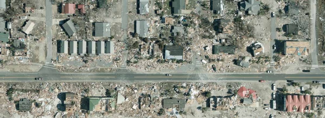
Disaster Response Program for Government Agencies available at no cost or obligation.
Introducing Subscription Image Service Solutions to Government Agencies

Vexcel Imaging introduces aerial image subscription for government agencies.
Feiyan purchases UltraCam Eagle Mark 3

The certified Grade “A” mapping company becomes the first client for the UCE M3 in China.
Introducing the new UltraCam Docking Station v3 SATA

Vexcel released a new Docking Station v3 SATA that is lighter, smaller and quieter.
New channel partnership in China

Top quality aircrafts combined with UltraCam systems, thanks to new channel partnership in China.
Vexcel Imaging opens office in China

Vexcel Imaging opens a new office and service point in Shenzhen, P.R. China.
Introducing the new Interface Panel Touch

The new Interface Panel Touch with enhanced usability is now available for our aerial systems.


